


POSTED 10:00 A.M. THURSDAY
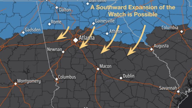
The area covered by the Winter Storm Watch posted Wednesday afternoon by the weather service has been expanded southward and now takes in all counties adjacent to Hall as well as other areas. And forecasters say it will likely be expanded even more. (See accompanying map).
Georgia not the only state bracing for the storm: Millions of Americans prepare for potentially catastrophic ice storm. Here’s what the numbers show – SRN News
EARLIER STORY. POSTED 4:00 P.M. WEDNESDAY – A Winter Storm Watch has been posted for this weekend for most of northeast and northwest Georgia, including Hall County for up to four inches of snow and sleet and a quarter inch or more of ice. Adjoining counties are also included except Gwinnett, Barrow, and Jackson, and metro Atlanta is not included.
NATIONAL WEATHER SERVICE (NWS) ADVISORY:
* WHAT...Heavy mixed precipitation possible. Total snow and sleet
  accumulations up to 4 inches and ice accumulations greater than one
  quarter inch possible.

* WHERE...Portions of north central, northeast, and northwest
  Georgia.

* WHEN...From late Friday night through Monday morning.

* IMPACTS...Expect power outages and tree damage due to the ice.
  Travel could be impossible. The hazardous conditions could impact
  the Monday morning commute.

PRECAUTIONARY/PREPAREDNESS ACTIONS...

Monitor the latest forecasts for updates on this situation.

Persons should consider delaying all travel Saturday and Sunday. If
travel is absolutely necessary, drive with extreme caution. Consider
taking a winter storm kit along with you, including such items as
booster cables, flashlight, shovel, blankets and extra clothing. Also
take water, a first aid kit, and anything else that would help you
survive in case you become stranded.