
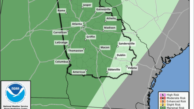
Several rounds of showers and thunderstorms are expected for the Gainesville area and most of Georgia on Tuesday but the outlook for Thanksgiving is clear and cool.
The National Weather Service (NWS) says these storms may be strong to severe and capable of producing gusty to damaging winds, large hail, and perhaps a tornado.
Meanwhile, above normal temperatures are likely to continue until midweek when we can expect a cool down which is expected to continue through next weekend with freezing temperatures Thanksgiving night and Friday night with rain returning Saturday night and Sunday.
The 7-day NWS forecast for Gainesville and vicinity:
Today
Mostly sunny, with a high near 68. Southeast wind 5 to 10 mph, with gusts as high as 15 mph.
Tonight
A 10 percent chance of showers after 5am. Mostly cloudy, with a low around 54. East wind around 5 mph.
Tuesday
A chance of showers and thunderstorms, then showers and possibly a thunderstorm after 7am. High near 67. East wind around 5 mph becoming south in the afternoon. Chance of precipitation is 80%. New rainfall amounts between a quarter and half of an inch possible.
Tuesday Night
Showers and possibly a thunderstorm. Low around 58. Southwest wind around 5 mph. Chance of precipitation is 100%.
Wednesday
A 20 percent chance of showers before 1pm. Mostly sunny, with a high near 67. West wind 5 to 10 mph, with gusts as high as 20 mph.
Wednesday Night
Mostly clear, with a low around 36.
Thanksgiving Day
Sunny, with a high near 51.
Thursday Night
Clear, with a low around 31.
Friday
Sunny, with a high near 51.
Friday Night
Partly cloudy, with a low around 31.
Saturday
Partly sunny, with a high near 50.
Saturday Night
A 20 percent chance of showers. Mostly cloudy, with a low around 38.
Sunday
A 40 percent chance of showers. Mostly cloudy, with a high near 52.