
2:00 P.M. FRIDAY UPDATE:
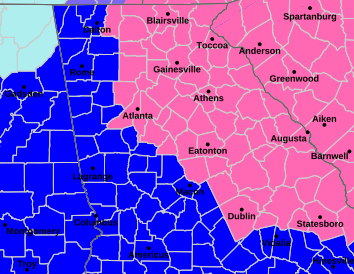
The Winter Storm Warning and Winter Weather Advisory area have been expanded to within a few miles of the Alabama line (See map) . Within the pink Warning area, 2-6 inches of snow are forecast, with locally higher amounts possible. Within the purple Advisory area, up to 1 inch of snow is currently forecast. Any snow accumulations will produce slick roadways and impact travel
5:00 A.M. FRIDAY UPDATE:
A Winter Storm Warning has now been issued all of northeast Georgia and parts of central Georgia. (On the map: pink is the Winter Storm Warning, blue is a Winter Storm Watch, and green is a Winter Storm Advisory.)
NATIONAL WEATHER SERVICE ADVISORY:
"*IN EFFECT FROM 1 AM SATURDAY TO 1 AM EST
SUNDAY...

* WHAT...Heavy snow expected. Total snow accumulations between 2 and
  4 inches with locally higher amounts possible. Winds gusting as
  high as 35 mph.

* IMPACTS...Roads, and especially bridges and overpasses, will likely
  become slick and hazardous. Gusty winds could result in areas of
  blowing snow and poor visibility. Plan on very difficult to
  impossible travel conditions.

* ADDITIONAL DETAILS...Wind chills will range from 5 degrees below
  zero to the lower teens above zero on Saturday and from ten degrees
  below zero to to the single digits above zero Saturday night.

PRECAUTIONARY/PREPAREDNESS ACTIONS...

Persons should consider delaying all travel. If you must travel, keep
an extra flashlight, food, and water in your vehicle in case of an
emergency. The latest road conditions for the state you are calling
from can be obtained by calling 5 1 1.

Persons are urged to stay indoors until conditions improve. If you
must go outside, dress in layers. Several layers of clothes will keep
you warmer than a single heavy coat. Cover exposed skin to reduce
your risk of frostbite or hypothermia. Gloves, a scarf, and a hat
will keep you from losing your body heat."
8:00 P.M. THURSDAY UPDATE:
The weather continues to fine-tune the ever-evolving forecast for the weekend. Here are key points from the mid-afternoon Friday advisory:
*(The snow) amounts will continue to be tailored heading into the weekend. Snow could begin as early as Friday evening over north Georgia and end through the day Saturday. Any accumulations will create slick roadways and dangerous driving conditions.” (Forecast snow amounts include 2.5 inches in Blairsville and Athens, 2-4 inches in Gainesville, trace-1 inch in Atlanta, and the chances diminish even more the farther west you go.)
*Extreme Cold Watch in effect. Hazardous wind chills expected especially Saturday night into Sunday morning, bottoming out at -2 just before daybreak Sunday. 48-60 straight hours of below freezing temps could lead to extended threat of pipe bursts and cold-related illnesses. Below freezing ground temps will allow snow to instantly stick to roads.
2:00 P.M. THURSDAY UPDATE:
The Winter Storm Watch has been expanded westward to include metro Atlanta and some places in west Georgia. It now extends as far west as a line from Calhoun to near Carrollton and Macon to Dublin, Vidalia, and Statesboro. (SEE EDITOR’S NOTE BELOW)
6:45 A.M. THURSDAY UPDATE:
A weekend Winter Storm Watch for our area and other parts of the state has now been posted by the weather service. (EDITOR’S NOTE: On the accompanying map, the shaded area in Alabama is not for a Winter Storm Watch but a Extreme Cold Watch.)
“WINTER STORM WATCH IN EFFECT FROM FRIDAY EVENING THROUGH SUNDAY
MORNING…
* WHAT…Heavy snow possible. Total snow accumulations up to two
inches possible. Winds could gust as high as 35 mph.
* WHERE…Portions of east central, north central, and northeast
Georgia.
* WHEN…From Friday evening through Sunday morning.
* IMPACTS…Plan on slippery road conditions.
* ADDITIONAL DETAILS…Wind chills will range from 5 degrees below
zero to the lower teens above zero on Saturday, then range from 10
degrees below zero to the single digits above zero Saturday night
into Sunday morning.”
Latest 7-day forecast for Gainesville and vicinity:
oday
Increasing clouds, with a high near 44. West wind around 5 mph.
Tonight
Partly cloudy, with a low around 26. West wind around 5 mph becoming calm.
Friday
Partly sunny, with a high near 43. Calm wind becoming east around 5 mph.
Friday Night
A slight chance of rain and snow before 10pm, then a chance of snow. Mostly cloudy, with a low around 25. Northwest wind around 5 mph. Chance of precipitation is 30%.
Saturday
A 40 percent chance of snow. Mostly cloudy, with a high near 29. Northwest wind 10 to 15 mph, with gusts as high as 30 mph.
Saturday Night
Mostly cloudy, with a low around 14.
Sunday
Sunny, with a high near 33.
Sunday Night
Mostly clear, with a low around 20.
Monday
Mostly sunny, with a high near 43.
Monday Night
Mostly clear, with a low around 26.
Tuesday
Mostly sunny, with a high near 48.
Tuesday Night
Mostly cloudy, with a low around 31.
Wednesday
A 20 percent chance of showers. Partly sunny, with a high near 46.
ORIGINAL STORY. POSTED 4:00 A.M. THURSDAY:
“Snow will return to portions of Georgia this weekend (including the Gainesville area), with the highest probability of travel impacts in eastern Georgia,” the National Weather Service (NWS) declares in an advisory issued Wednesday night.
“Impacts for Atlanta are uncertain (about a 1 in 3 chance) and will depend on how far west the storm tracks. This will be an all-snow event, so (unlike last weekend) no freezing rain or sleet.”
The chances of 1-3 inches of the white stuff include 90-95 percent along the Georgia-South Carolina border from Clayton to the Augusta area; 90 percent in the Toccoa area; 80 percent in Athens; and 60 percent in the Blairsville, Cleveland and Gainesville areas, and even as far south as Milledgeville and Sandersville.
Last weekend, it was central and south Georgia that got snow while our area was dealing with sleet and freezing rain.
Oh, and it’ll be bitterly cold this weekend, as well, with another blast of arctic air.
The NWS 7-day Gainesville area forecast:
Thursday
Partly sunny, with a high near 44. West wind around 5 mph.
Thursday Night
Partly cloudy, with a low around 27. West wind around 5 mph becoming calm.
Friday
A slight chance of rain and snow showers between 1pm and 4pm, then a slight chance of rain showers after 4pm. Partly sunny, with a high near 42. Calm wind becoming east around 5 mph. Chance of precipitation is 10%.
Friday Night
A chance of rain showers before 10pm, then a chance of snow showers. Mostly cloudy, with a low around 24. Northwest wind around 5 mph. Chance of precipitation is 30%.
Saturday
A 40 percent chance of snow showers. Mostly cloudy, with a high near 29.
Saturday Night
Mostly cloudy, with a low around 14.
Sunday
Sunny, with a high near 32.
Sunday Night
Mostly clear, with a low around 18.
Monday
Mostly sunny, with a high near 43.
Monday Night
Mostly clear, with a low around 25.
Tuesday
Mostly sunny, with a high near 47.
Tuesday Night
Mostly cloudy, with a low around 29.
Wednesday
A 20 percent chance of showers. Partly sunny, with a high near 49.