
7:30 A.M. MONDAY:
As clean-up continues across northeast Georgia following weekend rains that caused road washouts and closings, the rainfall numbers from certain places the story of what was behind them. While Hall County escaped relatively unscathed, that was not the case in several mountain areas where rainfall was heaviest and most of the associated problems occurred. Cleveland, for instance, received 6.52 inches, Dahlonega 6.13, Clayton 4.92 and Blairsville 3.94 inches. Meanwhile, Hall County picked up 1.97 inches, according to National Weather Service (NWS) data collected at the Gainesville airport.
7:00 A.M. SUNDAY:
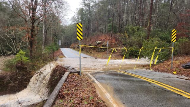
As expected, the rain had ended early Sunday morning, but the windy conditions remained as temperatures and wind chills plummeted. The National Weather Service (NWS) station at the Gainesville airport early Sunday showed rapidly falling temps overnight – from a reading of 53 at midnight to 42 at 6:00 a.m. Likewise, the wind chill fell right along with them, and by 6:00 stood at 37. Winds of 20 and 30 mph were constant. Meanwhile, cleanup is expected to continue in several places in northeast Georgia which were impacted by heavy rains and rising rivers and creeks. Some power outages and flooded roads were reported in Forsyth, Habersham and Lumpkin counties. In Lumpkin, Yahoola Creek Park is closed ’til further notice because of flooding, according to the sheriff’s office.
4:30 P.M. SATURDAY:
Some power outages and washed-out roads were reported in northeast Georgia Saturday afternoon as winds died down and the heavy rains subsided. Amicalola EMC appears to have been hardest hit with power outages reported in the Dawsonville, Jasper and Ellijay areas. In Habersham County, the sheriff’s office was warning motorists of washed-out roads or roads with fast-moving water flowing across them. The National Weather Service (NWS) still says the rains will continue into the night before windy and falling temperatures take over Sunday
2:15 P.M. SATURDAY:
The severe weather threat has ended across north and central Georgia. Rain will continue to push eastward through the afternoon, with the area drying out by the evening. Localized areas that experienced flooding earlier in the day should see waters recede this afternoon.
8:30 A.M. SATURDAY:
A Tornado Watch is in effect for portions of far northwest and west-central Georgia as a line of severe thunderstorms continues to track through Alabama.
8:30 P.M. FRIDAY UPDATE:
NATIONAL WEATHER SERVICE (NWS) ADVISORY:
“In addition to the Flood Watch in effect for parts of North Georgia, we’ll also have the potential for a few severe storms overnight into Saturday AM across most of North and West-Central GA. The primary threat is damaging wind gusts, but there is also potential for a brief tornado or two, especially in West-Central GA.
Remember to have a way to receive warnings, especially while you are sleeping! #gawx”
5:00 P.M. FRIDAY POST:
A Flood Watch has been posted for parts of Georgia. And while Hall County is not included, it does include some bordering counties, such as Forsyth and Dawson.
“We have issued a Flood Watch across parts of north Georgia until tomorrow (Saturday) evening,” the National Weather Service (NWS) wrote in announcing this development Friday afternoon. “Widespread rainfall of 2-3 inches is expected, with as much as 4+ inches in localized areas. This could lead to localized flash flooding, mainly in poor drainage areas and along creeks/streams prone to rapid rises. #gawx.”
Forecasters had warned earlier in the day heavy rains were likely through Saturday, leading to a rapid department from the Springlike temperatures of the past several days.
EARLIER STORY. POSTED AT 7:15 FRIDAY MORNING: NWS: From springlike temps to heavy rain to bone-chilling cold…