
Has the run on the grocery stores for milk, bread and other essentials begun? After all, the weather service and other outlets keep beating the drum about the possibility of, well, “you know what” “this weekend though the chances for the Gainesville area are less than 20%.
Here’s the latest advisory from the National Weather Service for our area and the rest of the state:
“A cold front will move through the area Friday night into Saturday morning, bringing light rain showers and cooler temperatures behind it.
Another system will move across the Southeast U.S. Saturday night through Sunday and will have the potential to bring snow / wintry mix to the region.
To put it simply, a lot. Model guidance has a very wide spread on the potential track of the second system, ranging from no snow/impacts, to widespread snow and significant impacts. This is leading to very low confidence in the forecast.
What You Can Do Now
Anticipate the possibility for travel impacts on Sunday Stay tuned for forecast updates and only follow trusted sources for weather information.”
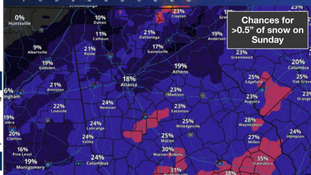
The advisory also includes a map showing the estimated likelihood of snow of half-an-inch or more in various places. It ranges from 23% in Clayton to 21% in Dahlonega to 17% in Gainesville with chances increasing into the 30%-40% range the farther south you go.
The NWS 7-day outlook for Gainesville and vicinity:
Today
Sunny, with a high near 48. Southwest wind 5 to 10 mph, with gusts as high as 15 mph.
Tonight
Showers likely, mainly after 2am. Mostly cloudy, with a low around 37. South wind around 5 mph, with gusts as high as 15 mph. Chance of precipitation is 60%. New precipitation amounts between a tenth and quarter of an inch possible.
Saturday
A 30 percent chance of showers, mainly before 7am. Partly sunny, with a high near 49. West wind 5 to 10 mph, with gusts as high as 20 mph.
Saturday Night
Mostly cloudy, with a low around 28. Northwest wind 5 to 10 mph, with gusts as high as 15 mph.
Sunday
Mostly sunny, with a high near 38. West wind around 10 mph, with gusts as high as 20 mph.
Sunday Night
Clear, with a low around 26.
M.L.King Day
Sunny, with a high near 45.
Monday Night
Mostly clear, with a low around 22.
Tuesday
Sunny, with a high near 42.
Tuesday Night
Clear, with a low around 24.
Wednesday
Sunny, with a high near 50.
Wednesday Night
A 20 percent chance of showers. Mostly cloudy, with a low around 34.
Thursday
A 20 percent chance of showers. Partly sunny, with a high near 55.