
POSTED 6:00 A.M. WEDNESDAY:
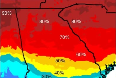
There’s an 80-90 percent chance that the ice storm expected to hit Georgia this weekend will impact our area. That’s according to the latest advisory from the National Weather Service (NWS).
Daytime temperatures in the 30s and nighttime lows in the 20s are expected. (See weekend forecast below). The storm will result in a loss of power, downed trees and powerlines and power poles, and extremely dangerous roads. In the meantime, state officials now is the time to prepare. (See separate story).
The NWS weekend forecast for Gainesville and vicinity as of 6:00 a.m. Wednesday:
Friday Night – A 50 percent chance of showers. Mostly cloudy, with a low around 32.
Saturday -Rain showers and snow showers likely, possibly mixed with sleet before 1pm, then freezing rain, possibly mixed with snow showers and sleet. High near 37. Chance of precipitation is 80%.
Saturday Night – Freezing rain, possibly mixed with snow showers and sleet before 1am, then freezing rain, possibly mixed with sleet. Low around 24. Chance of precipitation is 100%.
Sunday -Freezing rain before 1pm, then a chance of rain or freezing rain. High near 33. Chance of precipitation is 80%.
Sunday Night – A chance of rain or freezing rain before 1am, then a slight chance of snow showers. Mostly cloudy, with a low around 22. Chance of precipitation is 40%.
EARLIER STORY. POSTED 1:00 P.M. TUESDAY:
The National Weather Service (NWS) is now “confident” that a major winter storm will strike north Georgia this weekend, with our part of the state in the bullseye.
“We are confident that a major winter storm will impact the Eastern U.S. this weekend,” an advisory issued at noon Tuessday says. “What is less certain is where the worst of the winter weather will occur. Will there be significant impacts in Georgia? It’s possible but not certain given that we will be on the southern edge of the coldest air. For now, the highest level of concern is for parts of northeast Georgia.”
What should you do now?
“Monitor the forecast and be ready to take action if this (does) becomes a major winter storm. Consider how you would stay safe if you lose power or the ability to travel for a few days.”
EARLIER STORY. POSTED 7:45 MONDAY NIGHT:
The National Weather Service (NWS) says, while it’s still too early to forecast any definite, it’s looking more and more like north Georgia may be hit with a winter storm next weekend that could bring with it significant accumulations of snow and ice.
“We are seeing signals that impactful wintry weather may occur across parts of North and Central GA this coming weekend,” the Peachtree City Office advisory which was issued Monday afternoon says. “Details regarding who gets what, when, and the extent of any impacts, should become clearer in the coming days.”
The Gainesville area forecast for the weekend:
Friday Night
A 50 percent chance of rain. Cloudy, with a low around 34.
Saturday
Rain and snow likely, mainly after 1pm. Cloudy, with a high near 39. Chance of precipitation is 60%.
Saturday Night
Rain and freezing rain likely, possibly mixed with snow. Cloudy, with a low around 26. Chance of precipitation is 70%.
Sunday
A chance of rain, snow, and freezing rain. Mostly cloudy, with a high near 36. Chance of precipitation is 40%.
Sunday Night
A chance of snow and freezing rain. Partly cloudy, with a low around 20. Chance of precipitation is 30%.