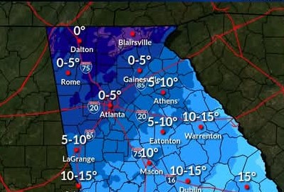
The National Weather Service (NWS) Friday issued its most definitive predictions for the arctic surge of air expected to invade Georgia early next week as well as the chances for another round of snow and/or ice Tuesday-Friday.
Maps accompanying the advisory show that Monday morning wind chills in Georgia are likely to range from zero along the Tennessee and North Carolina lines to 15-20 degrees as far south as Valdosta and zero-to-five-below in Gainesville and surrounding areas. The chance for snow and/or ice Tuesday-Friday runs from 27% in north Georgia to 24% as far south as Albany.
Here’s s the NWS midday Friday statement:
“Rain returns overnight (Friday) becoming widespread on Saturday. A few rumbles of thunder cannot be ruled out in far south-central GA. No widespread severe or winter weather is expected with this system. System exits on Sunday.
Following this weekend system, temperatures are expected to plummet! Temperatures around sunrise Monday morning are forecast at 10 to 25°F but breezy winds will result in ‘feels like’ temperatures in the single digits to low teens!
Forecast high temperatures Monday – Wednesday will range 20 to 30°F.
NOW is the time to prep for the cold! This is likely to be our most impactful cold snap of the season. Remember the 4 P’s Cold safety Info -> www.weather.gov/safety/cold
And finally, the thing on everyone’s mind — can we expect another winter storm to impact portions of Georgia?
What we know: Latest data suggests a timeframe sometime between Tuesday & Wednesday if impacts were to be felt in our area. Below: The chance of seeing > 1″ of snow.
Given expected temps & potential storm track – the whole state remains ‘in play’ for potential snow accumulations. While there is still quite a bit of spread in the potential position of the storm, PLEASE, PLEASE prep for extremely cold temperatures next week…”


