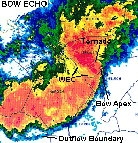
Though they were consistent with an EF1 tornado, the National Weather Service (NWS) has determined that it was straight-line winds that caused the damage in Forsyth County last Thursday.
Here is the NWS report on its findings:
“The NWS assessment concluded there was widespread significant wind damage and that a tornado path within that large scale wind damage was not discernible. The area of focus started on Oak Grove Circle southeast across Dahlonega Hwy, along Tallant Road and across Hopewell Road.
According to the NWS, radar data suggests that this region was located at the apex of a bowing segment (an arched/bowed out line of thunderstorms, sometimes embedded within a squall line) within the thunderstorm complex which had already caused significant widespread wind damage. Tree-fall patterns along Tallant Road, Hopewell Rd and south of Tallant Road along Dahlonega Hwy were more suggestive of straight line winds or downburst due to the fanning out pattern observed.
While it is possible that a tornado can form along a leading edge of a bowing segment which would resemble an eddy, whether or not that occurred was not discernable. Regardless, a wind event took place in this region which resembled mid range EF1 damage.
Several reporting stations throughout northern Forsyth County recorded wind gusts of 68 and 69 mph. Winds with these pockets of more intense tree damage, particularly along Tallant Road, is estimated to have been 90- 95mph.”
(NWS picture: Does not depict conditions in Forsyth County Thursday. It simply is an example of how a bow effect appears on radar.)


