
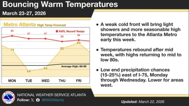
Temperatures are expected to bounce from above normal to seasonable and back to above normal through this week.
“A cold front will usher in increased cloud cover and cooler temperatures for Monday and Tuesday before above normal temperatures return after mid-week,” according to a Monday morning National Weather Service (NWS) advisory. “Some areas may be approaching (a) record high into late week.”
The accompanying graphic specifically highlights Atlanta, but similar trends are expected across all of North and Central Georgia all this week.
The 7-day outlook for Gainesville and vicinity:
Today
Partly sunny, then gradually becoming sunny, with a high near 74. West wind 10 to 15 mph becoming northwest in the afternoon. Winds could gust as high as 25 mph.
Tonight
Mostly clear, with a low around 43. North wind 5 to 10 mph becoming east after midnight. Winds could gust as high as 20 mph.
Tuesday
Partly sunny, with a high near 59. East wind around 10 mph, with gusts as high as 20 mph.
Tuesday Night
A 40 percent chance of showers, mainly after 2am. Mostly cloudy, with a low around 45. East wind around 5 mph.
Wednesday
A 30 percent chance of showers, mainly before 8am. Mostly cloudy, with a high near 58. East wind around 5 mph.
Wednesday Night
Mostly cloudy, with a low around 48.
Thursday
Mostly sunny, with a high near 76.
Thursday Night
Mostly clear, with a low around 58.
Friday
Sunny, with a high near 83.
Friday Night
A 20 percent chance of showers after 2am. Partly cloudy, with a low around 52.
Saturday
A 10 percent chance of showers. Mostly sunny, with a high near 66.
Saturday Night
Mostly clear, with a low around 41.
Sunday
Sunny, with a high near 63.