
Fall-like temperatures with a decrease in both humidity and chances for rain will dominate the weather this week across Georgia with Gainesville among the areas where night nighttime lows will dip into the 50s.
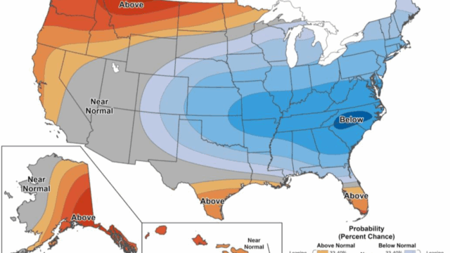
In fact, the whole eastern half of the country can expect below normal temperatures for the next 6-10 days.
The NWS 7-day forecast for Gainesville and vicinity:
Today
A 50 percent chance of showers and thunderstorms, mainly after 2pm. Mostly sunny, with a high near 85. Calm wind becoming west around 5 mph in the afternoon.
Tonight
A 30 percent chance of showers and thunderstorms, mainly before 7pm. Mostly clear, with a low around 63. Northwest wind around 5 mph becoming calm.
Monday
Sunny, with a high near 84. Northwest wind 5 to 10 mph.
Monday Night
Partly cloudy, with a low around 61. Northwest wind 5 to 10 mph, with gusts as high as 15 mph.
Tuesday
Mostly sunny, with a high near 80. Calm wind becoming northwest around 5 mph in the afternoon.
Tuesday Night
Partly cloudy, with a low around 57.
Wednesday
Sunny, with a high near 80.
Wednesday Night
Partly cloudy, with a low around 58.
Thursday
Partly sunny, with a high near 80.
Thursday Night
A 20 percent chance of showers after 2am. Mostly cloudy, with a low around 61.
Friday
A 20 percent chance of showers and thunderstorms. Mostly sunny, with a high near 79.
Friday Night
A 20 percent chance of showers and thunderstorms. Partly cloudy, with a low around 61.
Saturday
A 20 percent chance of showers and thunderstorms. Mostly sunny, with a high near 80.