
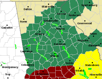
A Flood Watch remains in effect for a large portion of Georgia, including our area, but some counties in north Georgia are no longer in the affected area. A Flood Warning remains in effect for parts of Jackson and Barrow counties. Rainfall since midnight Friday at the Gainesville airport totaled 1.08 inches as of 7:00 Saturday morning. (MAP: Dark green counties are those included in Flood Watch; lime green indicates a Flood Warning.)
NATIONAL WEATHER SERVICE ADVISORY (ISSUED EARLY SATURDAY):
“Dawson-Lumpkin-White-Cherokee-Forsyth-Hall-Banks-Jackson-Madison- Paulding-Cobb-North Fulton-Gwinnett-Barrow-Clarke-Oconee- Oglethorpe-Wilkes-Carroll-Douglas-South Fulton-DeKalb-Rockdale- Walton-Newton-Morgan-Greene-Taliaferro-Heard-Coweta-Fayette- Clayton-Spalding-Henry-Butts-Jasper-Putnam-Hancock-Warren-Troup- Meriwether-Pike-Upson-Lamar-Monroe-Jones-Baldwin-Washington- Glascock-Jefferson-Harris-Talbot-Taylor-Crawford-Bibb-Twiggs- Wilkinson-Johnson-Muscogee-Chattahoochee-Marion-Schley-Macon- Peach-Houston-Bleckley-Laurens-Stewart-Webster-Sumter-Dooly-Crisp- Pulaski-Wilcox-Dodge-
Including the cities of Gainesville, Cumming, Atlanta, Dublin, Marietta, Homer, Washington, Pine Mountain, Carrollton, Watkinsville, Riverdale, Ellaville, Butler, Peachtree City, Comer, Covington, Crawfordville, Greensboro, Thomaston, Warner Robins, Warrenton, Commerce, Monticello, Roberts, West Point, Griffin, Abbeville, Monroe, Manchester, Hawkinsville, Macon, Zebulon, Winder, Talbotton, Toomsboro, Columbus, Buena Vista, Athens, East Point, Madison, Dahlonega, Louisville, Fort Valley, Eastman, Lumpkin, Sandersville, Dawsonville, Crawford, Jackson, Jeffersonville, Sparta, Preston, Eatonton, Cleveland, Americus, Franklin, Conyers, Barnesville, Douglasville, Forsyth, GIbson, Cordele, Milledgeville, Fort Moore, Woodstock, Wrightsville, Gray, Stockbridge, Newnan, Cochran, Decatur, Lawrenceville, Vienna, Dallas, and Montezuma
308 AM EST Sat Mar 9 2024 …
FLOOD WATCH REMAINS IN EFFECT THROUGH LATE TONIGHT…
* WHAT…Flash flooding caused by excessive rainfall continues to be possible. * WHERE…Portions of central, east central, north central, northeast, northwest, and west central Georgia, including the following areas, in central Georgia, Baldwin, Bibb, Bleckley, Butts, Crawford, Crisp, Dodge, Dooly, Houston, Jasper, Jones, Laurens, Monroe, Peach, Pulaski, Putnam, Twiggs, Wilcox and Wilkinson. In east central Georgia, Glascock, Greene, Hancock, Jefferson, Johnson, Taliaferro, Warren, Washington and Wilkes. In north central Georgia, Barrow, Cherokee, Clayton, Cobb, Dawson, DeKalb, Douglas, Fayette, Forsyth, Gwinnett, Hall, Henry, Lumpkin, Morgan, Newton, North Fulton, Rockdale, South Fulton and Walton. In northeast Georgia, Banks, Clarke, Jackson, Madison, Oconee, Oglethorpe and White. In northwest Georgia, Carroll and Paulding. In west central Georgia, Chattahoochee, Coweta, Harris, Heard, Lamar, Macon, Marion, Meriwether, Muscogee, Pike, Schley, Spalding, Stewart, Sumter, Talbot, Taylor, Troup, Upson and Webster.
* WHEN…Through late tonight.
* IMPACTS…Excessive runoff may result in flooding of rivers, creeks, streams, and other low-lying and flood-prone locations. Area creeks and streams are running high and could flood with more heavy rain.
* ADDITIONAL DETAILS… – Rainfall continues this morning across these areas. Heaviest rainfall is likely to be more confined to central GA, but given that 1.5-3″ has fallen across portions of the western I-85 corridor, the watch will remain in effect until rainfall ends. In portions of central GA, an addition 0.5″ to 1″ will be possible, especially over the next few hours, which could lead to flash flooding…”