
NATIONAL WEARHER SERVICE (NWS) FACEBOOK POST – 11:00 P.M.
“The Flood Watch has been extended southward to include much of central Georgia as…showers and thunderstorms could lead to flooding concerns overnight into Monday. The Flood Watch remains in effect through Monday evening.”
EARLIER POST – 2:15 P.M.
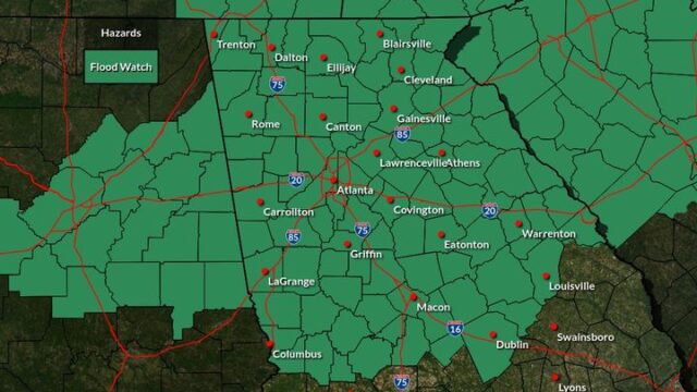
A Flood Watch has been issued for a large part of north and central Georgia, including Hall and surrounding counties, for tonight and tomorrow and tomorrow night.
- “WHAT, Flash flooding caused by excessive rainfall is possible.
- WHERE, Portions of central, east central, north central, northeast, northwest, and west central Georgia, including the following areas, in central Georgia, Baldwin, Butts, Jasper, Jones, Monroe and Putnam. In east central Georgia, Greene, Hancock, Taliaferro, Warren and Wilkes. In north central Georgia, Barrow, Cherokee, Clayton, Cobb, Dawson, DeKalb, Douglas, Fannin, Fayette, Forsyth, Gilmer, Gwinnett, Hall, Henry, Lumpkin, Morgan, Newton, North Fulton, Pickens, Rockdale, South Fulton, Union and Walton. In northeast Georgia, Banks, Clarke, Jackson, Madison, Oconee, Oglethorpe, Towns and White. In northwest Georgia, Bartow, Carroll, Catoosa, Chattooga, Dade, Floyd, Gordon, Haralson, Murray, Paulding, Polk, Walker and Whitfield. In west central Georgia, Coweta, Heard, Lamar, Meriwether, Pike, Spalding and Troup.
- WHEN, From 7 PM EST this evening through Monday evening.
- IMPACTS, Excessive runoff may result in flooding of rivers, creeks, streams, and other low – lying and flood – prone locations. Creeks and streams may rise out of their banks. Flooding may occur in poor drainage and urban areas.
- ADDITIONAL DETAILS…
- Several rounds of heavy rain are expected to impact areas approximately north of a line from Troup to Warren County tonight through tomorrow as a warm front lifts into the area. This front is expected to stall near central Georgia allowing gulf moisture to lift over. Widespread rainfall amounts of 2 – 4″ will be likely. This stalled front could also allow for repeated rounds of heavy, convective rainfall to occur over locations in northern GA that could lead to isolated higher amounts and flash flooding concerns, especially in and around urban areas.
- http://www.weather.gov/safety/flood
PRECAUTIONARY/PREPAREDNESS ACTIONS…
You should monitor later forecasts and be prepared to take action should Flash Flood Warnings be issued.”