
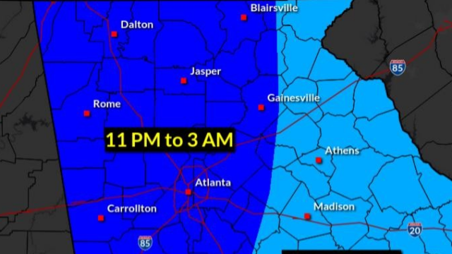
The line designating the eastern border of the most severe weather expected overnight in Georgia has been moved eastward by the weather service and now includes Hall County.
“Here is the latest anticipated timing for the potential severe weather overnight, broken down (see accompanying map) into three general time windows,” the National Weather Service (NWS) advised late Tuesday afternoon. “Be sure that you have a way to be alerted of Warnings while you are asleep tonight!”
What’s now possible for us? “Damaging winds around 60 mph are the primary hazard, though a couple of brief tornadoes could occur,” the NWS says.
Forecasters say to use a weather radio and/or ensure that Emergency Alert System (EAS) notifications are enable on your phone. “Remember – outdoor warning sirens are only intended to be heard if you are OUTDOORS.”
WIND ADVISORY, WARNING
In addition, a High Wind Warning is in effect until 7:00 Wednesday morning for Towns County, Gilmer County, Fannin County, Whitfield County, Catoosa County, Dawson County, Gordon County, Murray County, Walker County, Lumpkin County, Pickens County, White County, Union County, and Dade County.
Elsewhere, including Hall County, a Wind Advisory is effective until 7:00 Wednesday night for Putnam County, Hall County, South Fulton County, Paulding County, Coweta County, Bartow County, Fayette County, Douglas County, Jackson County, Gwinnett County, Cherokee County, Chattooga County, Spalding County, DeKalb County, Banks County, Oglethorpe County, Oconee County, Pike County, Greene County, Morgan County, Henry County, Polk County, Walton County, Clayton County, Madison County, Barrow County, Floyd County, Rockdale County, Cobb County, Butts County, Jasper County, Troup County, Haralson County, Lamar County, Heard County, Carroll County, Clarke County, Meriwether County, North Fulton County, Forsyth County, Upson County, Newton County.