
6:45 p.m. UPDATE: A Tornado Watch has been issued for parts of north Georgia, including Dawson, Lumpkin, and White counties. Please check here for the latest developments throughout the night: Peachtree City, GA (weather.gov)
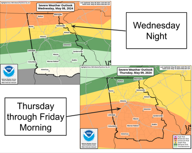
3:30 p.m. UPDATE: Strong to severe thunderstorms will be possible tonight into early Thursday morning. The dark green indicates a Marginal Risk (Level 1 out of 5) for severe weather while far west- central Georgia is under a Slight Risk (Level 2 out of 5) for severe weather. Damaging wind gusts of at least 60 mph will be the primary hazard, but a brief tornado cannot be ruled out. A secondary threat associated with potential MCS development will return Thursday afternoon into Friday morning. The main hazards associated with this will be damaging winds, brief tornadoes, and hail.
ORIGINAL STORY. POSTED 10 a.m.:
Severe storms, including possible tornadoes, are possible across north Georgia, including Gainesville and surrounding areas, and other parts of the state tonight into tomorrow.
NATIONAL WEATHER SERVICE ADVISORY:
“…We are expecting a strong to severe line of thunderstorms to affect north and central GA with the main threats being:
![]() Damaging wind gusts
Damaging wind gusts
![]() Brief tornado
Brief tornado
![]() Minor flooding in low lying areas”
Minor flooding in low lying areas”
Meanwhile, overnight Tuesday strong storms, including tornadoes, roared through parts of the Midwest.
Details here: Storms battering the Midwest bring tornadoes, hail and strong winds – SRN News