
FROM THE NWS:
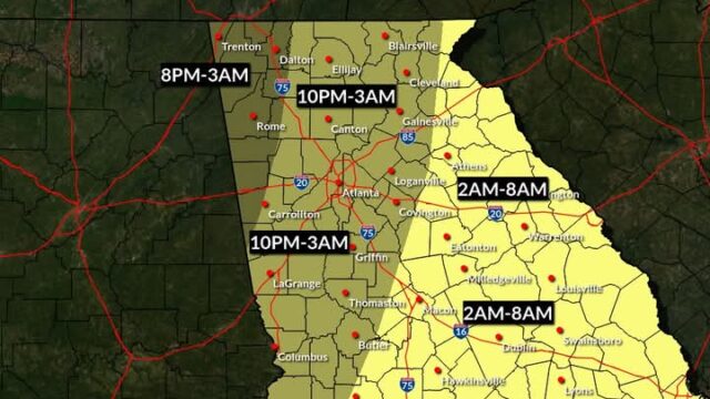
“Here is a rough timing of the greatest chance for severe weather. Thunderstorms, some even strong to severe, could still occur outside of these times. Stay tuned for further updates. #gawx”
***EARLIER STORY. POSTED 10:00 A.M. SATURDAY:
FROM THE NATIONAL WEATHER SERVICE (NWS):
“Changes of note:
The moderate risk (Level 4 of 5) has been expanded to include more of northwest GA due to increasing confidence in a damaging wind threat.”
At 10:00, a line of strong thunderstorms was moving into northwest Georgia just south of Chattanooga, tracking to the northeast.
You can keep up with the latest information at two NWS Peachtree City sites and the Hall County EMA Facebook page:
(20+) Facebook (NWS)
Peachtree City, GA (NWS)
(20+) Facebook (Hall EMA)
***EARLIER STORY. POSTED 7:30 A.M. SATURDAY:
(SRN NEWS/AP/97.5 GLORY FM)
A dynamic storm system threatening to spawn powerful tornadoes and hail as big as baseballs has earned a relatively rare designation from forecasters: A “high risk” day of severe weather.
Parts of Missouri, Iowa and Illinois saw some of the most extreme weather on Friday, with the system now taking aim at southern states.
“Numerous significant tornadoes, some of which should be long-track and potentially violent, are expected on Saturday afternoon and evening,” the federal Storm Prediction Center said in its latest forecast.
The Storm Prediction Center uses five categories to warn of expected severe weather, ranging from marginal to high. Its forecast maps are color-coded, with the lowest risk areas in green and the highest shown in magenta.
On Saturday, that area of highest risk includes parts of Mississippi and Alabama.
The “high risk” designation is used when severe weather is expected to include “numerous intense and long-tracked tornadoes” or thunderstorms producing hurricane-force wind gusts and inflicting widespread damage, according to the agency’s product descriptions.
On many days when the “high risk” designation was used in recent years, the forecasts became reality.
HALL COUNTY, JEMC PREPARE
Hall County’s severe weather threat for Saturday night into Sunday morning has increased over the past few days. This will be an overnight event that occurs while many are asleep.
The accompanying map shows that the county is still in a Level 3 (out of 5) warning area (orange) for heavy rains, strong gusty winds, possible tornadoes, and flooding.
What you should do to prepare for the worst?
*Identify a location to go to in the event of a warning such as an interior room in the lowes level of your home.
*Have your phones fully charged and alternate sources of light such as a flashlight.
*Go to alerts.hallcounty.org to sign up for weather alerts and have another notification method, such as a NOAA All Hazards Weather Radio.
Hall County Emergency Management reminds us that “outdoor warning sirens are designed to notify people who are outdoors to go indoors, not to wake you up while you are asleep inside your home. Do not count them as a notification method.”
Meanwhile, Jackson EMC (JEMC) has its own crews as well as contract crews standing by to respond power outages as soon as it’s safe to do so. And the electric co-op says to treat all downed utility lines, be they power, cable or telephone, as if they are “live” and leave them alone.