
It was ten years ago today that most of north and central Georgia was paralyzed by a major snowstorm that caught everyone from state emergency officials to school administrators to businesses off guard.
Atlanta was especially hard hit as workers started fleeing the city (some told to leave early by their bosses) when the snow began, and the warnings were issued. Snow amounts of 2 to 4 inches were widespread across north and parts of central Georgia with isolated amounts of near 6 inches in the mountains. In central Georgia 1 to 3 inches of snow was common along with 0.25 to 0.50 inches of ice.
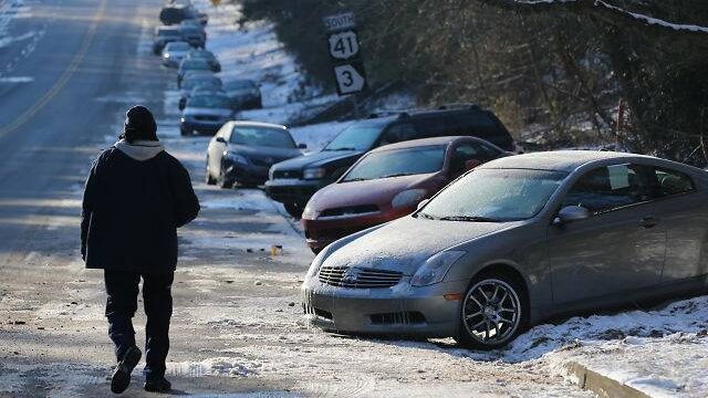
While only 1 to 3 inches of snow fell in the Atlanta metro area, tremendous traffic jams were caused by the icy roads which resulted in extremely long travel times. Some people were reported to have taken 6 hours to drive 30 miles. Others abandoned their vehicles and walked to their homes or to hotels. This littered the interstates and roads with abandoned cars. Others remained in their cars, trucks and buses for as much as 22 hours. Abandoned tractor-trailers also littered many roads.
The following is the National Weather Service’s (NWS) Event Summary of what happened January 28, 2014. (EDITOR’S NOTE: It is unedited and contains some metrological terms that are not defined in the report. )
NWS NARRATIVE:
“A cold arctic airmass that originated over northern Canada moved rapidly across the central United States on Monday, January 27, 2014. The advancing cold front moved rapidly out of the midwest and across north and central Georgia Monday night.
By Tuesday morning, January 28, 2014, temperatures were already below freezing across northwest Georgia, and by afternoon, north and west Georgia temperatures were below freezing. By Tuesday night freezing temperatures were reported across the entire area. During this time, a 500 millibar (mb) short wave was moving out of the southwest United States and into the western Gulf of Mexico.
By Tuesday this disturbance was spreading moisture out of the Gulf and across the Southeast. This resulted in a mix of winter precipitation across north and central Georgia with mostly snow across north Georgia, and a mix of freezing rain, sleet and snow across much of central Georgia.
The heaviest snow fell in a band from around Columbus to Milledgeville to Warrenton, and also in the northeast Georgia mountains where 2 to 4 inches fell, although higher amounts of up to 6 inches fell in the northeast Georgia mountains. Elsewhere 1 to 3 inches of snow fell. Freezing rain fell across central Georgia with the heaviest amounts south of a line from Columbus to Macon to Vidalia where a 1/4 to 1/2 inch of ice fell.
This storm caused tremendous impacts across the WFO Peachtree City warning area with power outages and slick roads. Although just 1 to 3 inch of snow fell over parts of the Atlanta metro area, thousands of motorists became stranded on roads and interstates, some for over 20 hours. Many motorists abandoned their vehicles leaving them along the sides of the interstates.
According to the Georgia State Patrol, there were over 1500 winter storm related accidents in Georgia and over 180 injuries. In the WFO Peachtree City county warning area, at least 2 deaths were attributed to the winter storm.”
(EDITOR’S NOTE: The storm led state officials from the governor on down to re-evaluate how to respond to such developments in the future.
The state Department of Transportation beefed-up the equipment it uses in response to winter storms and developed a plan to pre-treat roads and highways in an effort to keep them as free of ice and snow as possible. It began stockpiling mounds of salt along many major highways for quicker access when needed.
Many businesses changed their guidelines for closing early when the there is the threat of such a storm. Schools did the same.)
(Photo courtesy of NWS and John Spink/AJC)