
Preliminary rainfall totals from 7:00 Tuesday morning through 7:00 this morning show that many places in Georgia saw 10+ inches of rain, according to the National Weather Service (NWS). Gainesville received 8+ inches. For some of those places, the rainfall totals are unprecedented.
This count began with Predecessor Rain Event (PDE) and continued as what was left of Hurricane Helene moved out of the state Friday. As a result, NWS says, river flooding is continuing this morning and is likely to continue for the next several days.
Rainfall totals statewide ranged from less than an inch in extreme southeast Georgia along the Florida line to more than 13 inches in places in extreme northeast Georgia where officials ordered the evacuation of homes south of the dam at Lake Rabun in anticipation of a water release to take pressure off the structure and prevent it from collapsing.
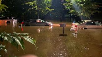
Ten-plus-inch readings were common in metro Atlanta where massive flooding was taking place.
Wind gusts of 50 mph and more were recorded across north Georgia as the storm moved through about mid-morning Friday. The top gust at the Gainesville airport was 41 mph which occurred about 9:00.
So, what’s the outlook now, as clean-up continues, and many places continue to deal with flooding?
All warnings and watches in Georgia have expired, save for Flood Warnings in Barrow County and a few other places scattered around the state.
The NWS says the outlook statewide for the next seven days across Georgia is for highs gradually warming from the 70s this weekend to the 80s by mid-week with lows holding in the 60, with little chance of rain.
(Picture: Atlanta flooding. Courtesy SRN NEWS/foxweather.com)